 Hikes
Hikes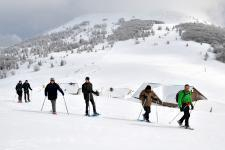 Mountain leaders
 Around us
")

")
Walking tour: Molkenrain and Camp Turenne
Nearest train station :
14 km - Cernay


About the walk
path
Start :
Uffholtz Route des Crêtes - Col du Silberloch
Altitude difference :
350 m
Length :
8,5 Km
Useful information
historical/heritage path
hiking path
IGN walking map needed :
1/25000 3620 ET
Marking :
Difficulté : intermédiaire

Departing from the Silberloch pass, in front of the National monument of the Hartmannswillerkopf - Vieil-Armand, which is a battlefield of WWI, go for a hike without any particular difficulties through the stubble to discover beautiful panoramas. but it is necessary to take the time to visit and observe the remains around you: castle ruins, monuments of remembrance...